Continued from previous page about:
Currents
Tidal stream data
Crossing a strong current
Going against the current
More about currents
![]()
Going against the current - shallow water Strong currents, rough water Some extreme currents Currents not caused by the tides Overfalls & tide races Large eddies & whirlpools
Contents Of Sea & Weather Chapter Wind Waves Tides Predicting The Weather Professional Weather Forecasts
 |
Continued from previous page about:
Currents
Tidal stream data
Crossing a strong current
Going against the current
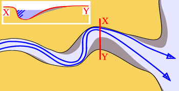 |
In an estuary with a bed of sand or gravel, the main channel usually bends (meanders) from side to side. The fastest current and the deepest water are at the outside of each bend. You can sneak upstream against the current by going round the inside of the bend. |
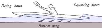 |
Here's a bit of shallow water physics. The faster you go, the more the back of your kayak is sucked downwards. It's more effective to go more slowly or move out to deeper water. Another illustration courtesy of Alan Byde. |
If a strong current is in conflict with wind or waves going the other way it often creates rough conditions. See Wind-Against-Tide Conditions and Swell-Against-Current Conditions.
Things can also get rough if a strong current is constrained by shallow water or a headland. See Overfalls & Tide Races, below.
You can find tidal horrors in parts of the world with a large tidal range (4 metres or more) and where local geography constricts tidal streams so they speed up. We can't resist listing some. We expect you can safely kayak past all them at slack water on neap tides, but please make enquiries locally first!
The world record for a current in the sea is held by the Saltstraumen near Bodø, in Norway. As the Skerstadfjord fills and empties, the water has to get through a gap about 150 metres wide. The average speed of the water is 7-9 knots. It has been estimated that peak flow is 20 knots and this creates colossal whirlpools. See Large Eddies & Whirlpools, below.
In British Columbia, tidal streams often reach 13 knots in the Seymour Narrows on the eastern side of Vancouver Island, and are reported to reach 17 knots in the Nakwakto Rapids at the end of Slingsby Channel, near Cape Caution. Go to the tidal stream pages of www.kayarchy.com for more about currents in Canada and the USA.
The whole of north-west Europe has a large tidal range and many fast tidal streams. Off the Cotentin peninsula in northern France and round the island of Alderney is an area of fast currents known in English as the Swinge and the Race and in French as the raz Blanchard. See the tidal stream atlas sample page. Alderney is one of the Channel Islands or îles anglo-normandes. There are several channels between the islands where kayakers may suddenly notice a lighthouse or small island apparently charging straight towards them, making a wake like a supertanker in a hurry. Tidal streams can reach 13 knots and there can be dangerous overfalls, especially when a strong wind blows against the tide. The Channel Islands are a great area for sea kayaking. Even the waters round Alderney are calm at slack water, and a popular destination for yachtsmen. From a sea kayaker's point of view, the distance to safety is never very great but you do need a good understanding of tide tables, charts and the tidal stream atlas.
The coast of Britain is mainly quite exposed to the open sea and it has strong tides driven by a large tidal range. Even so, 99% of it is safe for intermediate kayakers on a nice day. Apart from the Alderney race, Britain's tidal stream record-holders are as follows.
• Off the north coast of Scotland is the Pentland Firth where the flood tide going from the Atlantic to the North Sea pours through the gap between Scotland and the isles of Orkney. You can have a nice kayak trip in the Firth when the weather and tides are right, but beware the effect of wind against tide, and the navigator with shaky arithmetic. Local currents can reach 10 knots and they create dangerous conditions when the tidal stream conflicts with strong winds. This area is very exposed to north Atlantic gales which have been known to lift stones from the cliffs at Dunnet Head and send them crashing through the windows of the lighthouse, 105 metres above sea level.
In the words of the North Sea Pilot for 1875 "the hatches of small vessels ought to be secured even in the finest weather" before they enter the Firth "as... the transition from smooth water to a broken sea is so sudden that no time is given for making arrangements". The worst spots in the Firth have colourful names. At the Bore of Duncansby and the Merry Men of May, the 1875 Pilot said that with some combinations of tide, wind and waves, "a sea is raised which cannot be imagined by those who have never experienced it".
• The Menai Straits, between Anglesey and the mainland of Wales. A narrow channel where tides run at up to 8 knots. A very popular area with leisure boaters of all sorts, but not a comfortable place to be at mid-tide, especially if the current conflicts with a strong wind blowing the other way. The narrowest part of the Straits is known as the Swellies, and contains a number of small islands which divide and compress the current into channels only a hundred metres wide. When spring tides are running fast, the Swellies deserve to be treated like a white-water river. Expert kayakers can play there, novices may get bad fright if they venture into the powerful eddies that form downstream of the islets. Standing waves form where the water pours over shallow ledges of rock at Gored Goch (the islet with the cottage). Inspect from the bank before use. Two magnificent 19th century bridges cross the narrowest part of the Straits. Watch out for halfwits throwing coins and pebbles off Thomas Telford's iron suspension bridge, thirty metres above your head.
• Bardsey Sound, between the nature reserve of Bardsey Island and the Welsh mainland. It is at the tip of the Lleyn Peninsula, which sticks out thirty kilometres into the Irish Sea. Tidal streams run at up to 6 knots for most of the 3 kilometre width of the Sound, hence the Welsh name Ynys Enlli, meaning island of currents. One way over, depending on the state of the tide, is to do a colossal ferry glide at slack water. See Ferry Glides. The current creates overfalls in shallow water at the northern tip of Bardsey, and at two points on the nearest part of the mainland, but they are marked on the chart and in fine weather they can easily be seen, heard and avoided.
In north-west Europe, British Columbia, Maine and other areas with a big tidal range, most coastal currents are created by the rise and fall of the tide and most flow in alternating directions (reversing currents). Most of the rest of the world has a small or very small tidal range so other factors become more important.
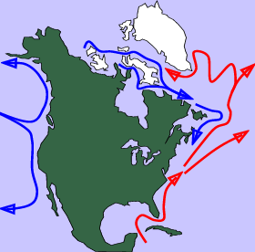 On a planetary scale, many ocean currents are caused by steady global winds, and by convection and water density. The Gulf Stream is partly driven by the Trade Winds. See Ocean Currents. The map shows the main ocean currents around north America.
Water density basically means salt content. Salt water is heavier than fresh water, because it contains dissolved salts. On a small scale, this means that estuaries often have a layer of fresh water on the top, from the river, lying on top of a layer of salt water that has come in from the sea.
On a large scale, water density creates a strange situation in the Straits of Gibraltar, where the current flows continuously east at nearly 3 knots. It is driven by evaporation caused by hot, dry conditions in the Mediterranean. As evaporation lowers the water level in the Med, water rushes in from the Atlantic to replace it. Although the Atlantic water is salty, the Med is saltier because of all that evaporation. The water from the Atlantic is slightly lighter than the saltier water already there. As the surface current flows in, the saltier and therefore denser water flows out 300 metres down.
Tidal streams dominate the last few miles of most rivers, especially in low-lying areas. In an estuary, the normal direction of flow of the river will be reversed by the incoming tide. See Tides & Rivers.
At a surf beach there are very often longshore currents, flowing sideways along the beach in shallow water at walking pace. The reason is that a breaking wave consists of a lot of water rushing up the beach, and that water has to get back out to sea somehow. It goes sideways until it can go no further, and then it flows back out to sea in a narrow, intense "rip current" like a river. Waves don't generally break in a rip current, so a rip makes a constant gap in a wall of surf. That makes a rip current a good way for a sea kayaker to get through the surf line, either seawards or back to the beach, without getting wet.
A wind which blows continuously for several days over open water will create a surface current of up to 2% the speed of the wind. So a Force 5 wind may create a surface current of up to 0.42 knots. To a sea kayaker, this is overshadowed by the direct effect of the wind on a lightweight boat.
 If a fast current is constricted by a headland jutting out into the sea, or a channel between an island and the mainland, or it flows over an undersea reef, bar across a river mouth or rocky sill across the mouth of a fjord, it can behave just like a white-water river.
Expect tide races, which are often fun; tide rips which may be fun; and possibly overfalls. But don't worry. Tide rips and overfalls are usually marked on charts, especially those on 1:25,000 scale. The symbol is two or four horizontal wiggly lines, one above the other. Bad ones would get a mention in the pilot guide for the area and are unlikely to reach any great size except in storm conditions.
If you cross the area at slack water, which is the time when local tidal streams have stopped flowing one way and have not yet started flowing the other way, the water should be calm. You can find the time of slack water with a set of tide tables and a tidal stream atlas. If you want to be particularly careful, time your trip for neap tides as well.
If you failed to buy a chart or pilot book, or ask in the pub, you should still not have any difficulty at all avoiding a tide race or overfall. If you find yourself being carried swiftly towards a large roaring area of exploding waves, it's a good moment to move sideways across the current so that you go round it rather than through it.
Overfalls
Under certain conditions of wind, tide and swell, a tidal stream pouring over a rock ledge will generate breaking waves. The same may happen where a tidal stream pours through any shallow part of the sea or over deeper currents moving at a different speed. These areas are known as overfalls.
Sea kayakers quite often use this word when referring to cuddly little standing waves that your grandmother would enjoy surfing. When other seafarers use the word they mean something quite nasty, and certainly the overfalls on a chart are marked because they're a hazard to shipping.
The International Hydrographic Organisation is responsible for consistent worldwide standards in nautical charting. Its Hydrographic Dictionary defines overfalls as "short, breaking waves occurring when a strong current passes over a shoal or other submarine obstruction or meets a contrary current or wind". Bowditch's American Practical Navigator defines them as "breaking waves caused by the meeting of currents or by waves moving against the current".
Their nature changes constantly with changes in the height of the tide, the speed and direction of the tidal stream, the speed and direction of the wind, and the size of any swell.
It is well worth going around overfalls, rather than through the middle, and some can be just terrifying at peak flow. There are plenty amongst the little islands off the south-west tip of Wales. Click here to see a chart extract, and for more information see Holes and Example Of A Hole.
Tide races & rips
According to the Hydrographic Dictionary and Bowditch a tide race is simply "a strong tidal current or a channel in which such a current flows"..."a very rapid tidal current through a comparatively narrow channel".
A tide rip consists of "waves formed on the surface of water by the meeting of opposing tidal currents or by a tidal current crossing an irregular bottom. Vertical oscillation, rather than progressive waves, is characteristic of tide rips"... "agitation of water caused by the meeting of currents or by a rapid current setting over an irregular bottom". Not to be confused with a rip current at a surf beach.
When water pours through a narrow channel, round a headland or over a shallow ledge of rock, it may create a tide race. On a calm, sunny day that often means an attractive procession of smooth stationary waves.
Small and medium-size wavetrains are perfect for practicing surf technique. See Standing Waves. In any case, a kayaker can usually get past a tide race on the inside by staying very close to land.
Any tide race can be deeply unfriendly in strong winds or with a big swell running. It may become an area of fast turbulent water with confused breaking waves.
Small
On a calm day, a small tide race like the one at Hartland Point can provide a few minutes of wet fun for experienced kayakers. There is a video of sea kayakers going through the race at North Stack, Anglesey, Wales on YouTube. Search on "North Stack Tide Race" or try http://www.youtube.com/watch?v=i1MhINOj4QQ
Medium
In a few places you will find a tide race where experts will happily play for hours. There's a good video on YouTube of sea kayakers in the mouth of the Indian River, Delaware. Search on "Surfing The Tide Race" or try http://www.youtube.com/watch?v=tp4iGi_AET8
Significant tide races are not all that common even on the Atlantic coast of Europe which has a very large tidal range. Most are off rocky coasts with headlands reaching out into the ocean. Even in Britain with its small land mass and great vertical tidal range, you may need to drive for six hours to spend the weekend playing on a good one. Elsewhere we list some and discuss what makes a friendly wavetrain, and what makes an unfriendly one.
Big but OK
Big tide races, like the one that often appears off Lands End, Cornwall, may flow as fast as a kayak can sprint. On a calm sunny day, seen from the rock-climbing cliffs, kayakers struggling to round the headland the wrong way look like tiny dots of colour against black water and often disappear behind huge oily waves. Memorable but not recommended.
Big and nasty
A tide race is not usually dangerous but in windy conditions its standing waves can steepen and break colossally.
A really big tide race may, at peak flow, always have breaking waves which could keep you underwater for long enough to make you give up sea kayaking.
During spring tides there is often a large roaring area of exploding waves at Start Point in Devon and Portland Bill in Dorset. It takes only a 4 knot current and some wind to create a heavy tide race at Start Point. The photo above shows it on a windy day, at peak flow on spring tides. See the lighthouse? The largest breaking waves are more than 2.5 metres high. The tiny white dot in the centre background is the sail of a yacht taking the long way round. At slack water this area is often a calm and lovely vista of clear green-blue water.
Hilaire Belloc, poet and pre-war politician, was also a yachtsman who had been through Alderney Race, Wildgoose Race off Pembrokeshire, the St Aldhelm's Head race and the Skerries off Anglesey but considered Portland Race "the master terror of our world". In The Cruise Of The Nona (1925) he noted that during the First World War it "sank a ship of 14,000 tons, loaded with machinery... I have seen Charybdis - piffling little thing... Portland Race could eat [it] and not know it had had breakfast. I have nearly always been successful in catching the smooth, narrow belt [inshore] near the point; but I also once found that smooth belt fail me, and so have gone through the tail end of Portland Race; only the very tail end... it is one of the wonderful works of God... [it] lies in a great oval, sometimes three, sometimes four or five miles out from Portland Bill, like a huge pendant hanging from the tip of a demon's ear. It is greater or smaller, according to whether the wind be off-shore or on, but it is immense always, for it is two miles or more across. It lumps, hops, seethes and bubbles just like water boiling over the fire, but the jumps here are in feet and the drops are in tons... it is a chaos of pyramidical waters leaping up suddenly... it purposely raises a clamour [which] resembles a gigantic pack of fighting dogs... and all these things you find out if you get mixed up in it in a very small boat... .."
Currents in the sea flow like a river but on a larger scale, so small eddies form downtide of rocks, man-made objects such as buoys and bridge columns, and any other obstructions.
Large eddies form downtide of islands and headlands. Click to go to two diagrams. Usually, eddies spin lazily so that the water on one side flows with the tide, the centre rotates on the spot, and the water on the other side flows in the opposite direction to the tide. This provides the experienced sea kayaker with a way to travel against an adverse current, by going from eddy to eddy.
In the few areas of the world which have unusually strong tides, eddies may form alarming swirls and boils on the surface of the sea. For example, amongst the maze of little islands off the south-western tip of Wales. If an area of eddies is a threat to larger boats or may affect the navigation of ships it will be marked on a nautical chart by little spirals.
Where there is a particularly strong local current flowing past an island or headland it may create a whirlpool. A whirlpool is a large, powerful eddy, the centre of which is noticeably lower than sea level. Visit the site of a whirlpool at a period of neap tides, or when slack water when the current is about to change direction, and you will see calm water. Visit at spring tides and maximum flow and you will see and hear violent white water. Whirlpools are seldom any real threat as the large ones are so obviously dangerous that you will stop some distance away, but they can still become legendary.
The world record for a current in the sea is held by the Saltstraumen near Bodø, in Norway. As the Skerstadfjord fills and empties, the tidal stream has to squeeze through a channel about 150 metres wide. The average top speed of the water is 7-9 knots. It has been estimated that peak flow is 20 knots. This generates a series of whirlpools 10 to 15 metres across and apparently up to 6 metres deep. These can be viewed from 40 metres above by stopping on the Riksvei 17 road bridge.
The largest tidal whirlpool in North America is the Old Sow, off Deer Island in the Bay of Fundy. A suitable feature of the area with the world's largest tidal range. A suitable feature of the area with the world's largest tidal range. The only kayaking incident we've heard of involved a couple who went too close so the wife had to be towed back out by a motorboat. All the US Coastal Pilot has to say about it is "whirlpools and eddies which are dangerous to open boats...during spring tides the flood attains a velocity of about 6 to 7 knots".
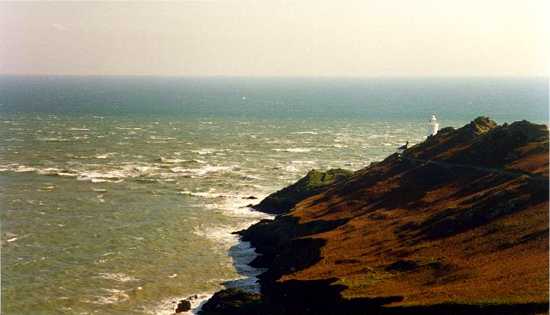
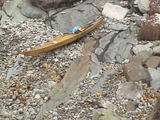
In Britain, the Hag of Corryvreckan or Corrievreachan (Coire Bhreacain in Gaelic) has a certain reputation. It forms at certain times in a narrow channel between the islands of Jura and Scarba, in Scotland. The Hag can sometimes be heard roaring from a distance of 12 kilometres and it's said to be able to swallow a fishing boat and spit out matchsticks. It's a spectacular piece of water at some states of the tide, and very dangerous for boats the size of a kayak. However it's generally possible to go past on the other side of the channel, and at slack water on a neap tide people have even swum through the Hag from the adjoining beach. Here's a kayak on that beach - at slack water.
The view is nice and you can carry on out to the Garvellachs for a great day trip. The curious can take a powerboat ride from Easdale into the heart of the Hag:
There are a few, a very few powerful little whirlpools which are so compact that they are unlikely to affect anything larger than a kayak and are therefore not marked on the chart. For example at the Falls of Lora on the west coast of Scotland. See Standing Waves.
We know of only one really dangerous little whirlpool. It is downtide of Horse Rock, Pembrokeshire, and lies on a direct route from the B-tches to the beach at the St Davids lifeboat station, St Justinian. When tidal conditions are just right, even when the waters flowing through Ramsey Sound are generally smooth, Horse Rock is usually underwater. It can create potent whirlpools which can make just one of a group of kayakers disappear completely for five seconds. Some unlucky folk have stayed down a lot longer than five seconds, and this area is now described by the Welsh Canoe Association as a "no go" zone.
Horse Rock appears on the chart extract we use in the chapter on sea kayak navigation. It is between the northern half of Ramsey Island and the mainland, just next to the deep water channel. It is shown as a small round object which is stated to be 0.9 metres above the level of the lowest tides. Note that immediately alongside it is the symbol for a wreck with masts visible at low water.
Go to next page for:
• Predicting The Weather